In the last week there has been a great deal of focus on what happens when people post photos on social media and how, in some cases, their images confirm their commission of a crime of breaking and entering.
Clearly you should not commit crimes, it is surprising when some people incriminate themselves doing just that. You may have seen in the news that the Parler website has had all uploads for the day of the US Capitol Riots saved which can be used later by federal investigators to charge those involved in the attacks (https://www.thesun.co.uk/news/13715892/hacker-saves-parler-posts-incriminating-evidence-capitol-riot/) .
So how can a photo from a smartphone that is posted show someone is at a certain place at a certain time if it is inconclusive as to where the image was taken? The answer is Metadata, that’s basically information which is associated with the photo. This is, for photos, called EXIF Data. EXIF is simply an acronym for “Exchangeable image file format”. It is a standard maintained by the Camera and Image Products Association (http://www.CIPA.jp) which exists to ensure technology for photography is consistent. EXIF outlines information which is to be saved as part of images or sound files. You’ll see things like a unique image ID, the dimensions/resolution as well as when the file was created etc. Basically, standard stuff but the one thing that makes this interesting is that there is GPS data associated with each photo. Every modern smartphone has a GPS receiver in it, and every photo taken on that phone has this data associated with the image.
EXIF applies to all modern smartphone Operating Systems of which the most popular currently are Android and iOS. Let’s look at a random picture I took years ago in London in 2011 at St Paul’s Cathedral. When Looking at the properties of the photo.
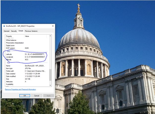
Meta Data Associated with a Picture
There are some neat features you can do with this data. As an Android user signed into Google you can, for example look at your history. I was on a business trip to German a year and a half ago and on the day before the meetings started, I went for a morning walk around Frankfurt and took pictures. My Google timeline shows my path sort of accurately walking along the Main River and going into the old town area and it shows me the photos I took while there and when. You can see when I was in the “Romberg” section of town I took a few pictures of the square there. This functionality is extremely useful to remember what days you did what and where.

Value Add Using EXIF Data
As you can see metadata can be a friend to you helping to relive travel, or even looking up what day you went somewhere. But of course, of you are breaking laws it’ll also be the best friend of law enforcement, remember data tends to be near immortal in the cloud.
